

Error message
By Ekaterina Antsygina
![]()
PhD Candidate, Queen’s University, Canada
ekaterina.antsygina@gmail.com
Posted: April 23, 2021
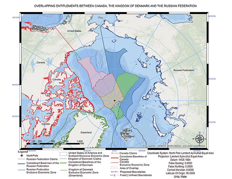
The delimitation of extended continental shelves, or ECS, is a relatively new phenomenon, and many agreements will be concluded in the coming decades. The Central Arctic Ocean, or CAO, is a special case, since the vast ECS entitlements of Russia, Denmark, and Canada overlap there (see Figure 1). The extent of the US entitlement is not yet known. It will probably overlap with the Canadian entitlement, but it will not reach the North Pole, which means that only Russia, Canada, and Denmark will participate in the division of the seabed in the heart of the Arctic.
Delimitation pending delineation
The Arctic coastal states are in the process of delineating their ECS, which involves unilateral establishment of the shelf’s outer limits. Parties to the United Nations Convention on the Law of the Sea (UNCLOS),i shall delineate following Article 76. If the outer limits are established on the basis of the recommendations issued by the Commission on the Limits of the Continental Shelf (CLCS), they are considered as final and binding, i.e., opposable to all the parties to the UNCLOS.
Although delimitation of ECS is legally possible before the delineation process is completed,ii in the case of the CAO there is no need to commit to any delimitation scenario until the coastal states achieve international recognition of the outer limits of their ECS. There are two reasons for this conclusion.
First, delimitation between states with opposite coasts requires the overlapping entitlements to be determined. In the case of adjacent coasts, the direction of the seaward segment of a maritime boundary can be determined without specifying its precise terminus by indicating that the delimitation line continues until it reaches an area where the rights of third parties may be affected (see Figure 2).iii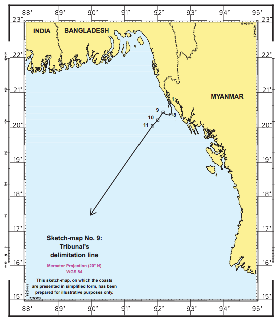
In the case of opposite coasts, such as those of Denmark and Russia, or Canada and Russia, certainty on the outer limits of the ECS is necessary to determine the extent of the entitlements and that they actually overlap. Until the Arctic states delineate on the basis of the CLCS recommendations, there is no certainty that the outer limits of the ECS will not changeiv or be challenged by other states.
On 31 March 2021, Russia submitted two addenda to its submission in respect to the Arctic Ocean, expanding its claim to further overlap those of Denmark and Canada. This might pressure Canada to resubmit its data to the CLCS as well and include areas of Alpha Ridge, Mendeleev Rise, and probably even the Chukchi Borderland that would overlap Russia’s claim. Denmark can also submit addendum to its submission, thus enlarging the areas of overlapping entitlements with Russia and Canada.
Each state is potentially entitled to larger areas of the Arctic seabed than were originally included into submissions. The decision on the extent of the submission is political: before this March, Russia and Canada followed a moderate approach and included in their submissions areas that they would expect to receive after the delimitation, while Denmark pursued a maximalist approach.
During the negotiations, all states could have agreed that the relevant area would be not what they included in their submissions but what they are entitled to. However, it seems that Denmark and Russia prefer to consider the relevant area of the delimitation to be the area of the overlapping submissions, which is more transparent for the general public but is not legally necessary. Now Ottawa has to decide whether to follow Russia and Denmark. The addenda to the submissions might postpone the conclusion of a delimitation, which is likely to happen after the delineation process is finalized.
Second, one of the incentives for prompt resolution of a maritime dispute is the presence of natural resources in the area of overlap. As all the states with overlapping entitlements have the right to exploit natural resources pending the delimitation, states are motivated to conclude a delimitation agreement to establish their exclusive jurisdiction. Because the probability of finding natural reserves in the CAO is low, there is no need for the Arctic states to expedite the delimitation. Nevertheless, they can initiate consultations on delimitation pending delineation.
Possible methods of delimitation
International law does not impose any obligatory method of delimitation for continental shelves. According to Article 83, the only requirement is to achieve an equitable result. In my view, this requirement is different for states and international dispute resolution institutions.v
For international tribunals, the notion of equity originates not only from the substantive law, Article 83, but also from their jurisprudence and the pursuit of legal unity, predictability, and stability. The international tribunals emphasize that there is no binding delimitation method and each case is unique, but they frequently prefer to apply the three-step approach for delimitation to minimize legal uncertainty.vi
States enjoy the freedom to delimit without using any particular rule or principle and do not need to justify the resulting boundary line. They merely have to concur that the agreed-upon borders are satisfactory. Hence, the Arctic states are free to use any delimitation method they wish. The North Pole is undoubtedly a point of conflict, although its importance is mainly symbolic since there are no resources around it. Nonetheless, it represents the Arctic.
Some delimitation methods might be more beneficial for Denmark but less beneficial for Canada and Russia. For example, the equidistance methodvii—which international tribunals apply as the first step of the three-step approach—is more favorable to Denmark because it would place the North Pole on Denmark’s continental shelf. States tend to start negotiations of a maritime delimitation by considering an equidistance line.viii
Canada and Russia, on the other hand, might prefer to establish the delimitation lines based on meridians, with the tripoint at the polar apex. Russia might appeal to the Sector Theory that was used to establish sovereignty of Canada and the USSR over the Arctic islands.ix
Notwithstanding its unconventional theoretical foundation, the Sector Theory was quite effective for land acquisition. I maintain, however, that since this approach was not intended to delimit maritime areas in the Arctic, it does not have a binding character in the case of ECS delimitation, but it might have a persuasive value.
Russia is a strong proponent of the use of the Sector lines in the Arctic: The delimitation agreement between the USSR and the United States in the Arctic Ocean is based on the Sector line,x and the delimitation agreement between Russia and Norway in the Arctic Ocean is a compromise between the median and Sector lines.xi But Canada might not cite the Sector Theory because its Sector was smaller than the area it expects to get as the result of the CAO delimitation. However, Canada has an interest in the North Pole and would pursue applying the meridian methodxii as the most convenient method of delimitation that involves the pole apex.
In my view, delimitation in the CAO should be performed simultaneously by Canada, Denmark, and Russia, through negotiations. The use of the equidistance method would be problematic due to the presence of the North Pole and the complexity of combining the equidistance lines between the three states. The states would probably pursue proportional division of the overlapping areas to ensure an equitable result.
What if the Arctic States cannot agree?
If Canada, Denmark, and Russia cannot reach an agreement on the delimitation through negotiations, they might refer to the UNCLOS dispute settlement mechanism. Although the UNCLOS established a compulsory dispute settlement procedure, parties could opt out of it for delimitation issues, so pursuant to the declarations of Russia, Denmark, and Canada, conciliation is the only compulsory method available for resolution of the dispute over the ECS in the CAO.xiii However, because the report of the conciliation commission is not binding upon the parties, cooperation on the delimitation is essential.
The Arctic states can reach an agreement to refer a dispute to the International Court of Justice, the International Tribunal for the Law of the Sea, or arbitration, but this is unlikely for two reasons: first, they would prefer to control the delimitation process, and second, the dispute resolution institutions would probably apply the three-step approach, which is not beneficial to Canada or Russia.
Hence, the delimitation in the Arctic will be accomplished through negotiations. Since the delineation will take 10 to 20 years, the states have time to negotiate and prepare a model delimitation agreement. There is no commercial viability of any activities in the zone of overlap that would require prompt delimitation or provisional arrangements for the use of the seabed in the CAO.
The views expressed are those of the author and do not necessarily reflect the policies or positions of the East-West Center or of any other organization.
End notes:
i United Nations Convention on the Law of the Sea (Montego Bay, 10 December 1982, in force 16 November 1994) 1833 UNTS 396.
ii See Delimitation of the Maritime Boundary in the Bay of Bengal (Bangladesh/Myanmar), [2012] ITLOS Rep 4, para. 367.
iii Delimitation of the Maritime Boundary in the Bay of Bengal (Bangladesh/Myanmar), [2012] ITLOS Rep 4, para. 367.
iv States can resubmit data to the CLCS.
v Ekaterina Antsygina, Bernardo Perez-Salazar, “Sovereign Rights on Extended Continental Shelves: The Case of the Nicaraguan Rise in the Caribbean,” The International Journal of Marine and Coastal Law vol 35 or vol 4 (2020): 772–800, at p. 795.
vi The approach was created by the international dispute resolution institutions to fill in the gaps in Articles 74 and 83 with regard to both the applicable methodology and the legal principles. David Anderson, “Developments in Maritime Boundary Law and Practice,” in International Maritime Boundaries, Volume V, eds. David A. Colson and Robert W. Smith (Leiden/Boston: Martinus Nijhoff Publishers, 2005), at p. 3209.
vii An equidistance line is a line every point of which is equidistant from the coastlines from which the breadth of the territorial sea of each two States is measured. UN, Division for the Ocean Affairs and the Law of the Sea, Handbook on the Delimitation of Maritime Boundaries (Location: United Nations, 2000), at p. 47.
viii L DM Nelson, "The Roles of Equity in the Delimitation of Maritime Boundaries," The American Journal of International Law, 84:4 (1989): 837, at p. 844 citing Prosper Weil, The Law of Maritime Delimitation – Reflections (Cambridge: Grotius Publications Limited), at p. 154.
ix Janice Cavell, “The Sector Theory and the Canadian Arctic, 1897–1970,” The International History Review, 41:6 (2019): 1168–1193; W. Lakhtine (1930) “Rights over the Arctic,’” American Journal of International Law, xxiv.
x The Agreement between the United States of America and the Union of Soviet Socialist Republics on the Maritime Boundary, Washington 1 June 1990 (not in force).
xi Rolf Tamnes, Kristine Offerdal (eds.) Geopolitics and Security in the Arctic: Regional dynamics in a global world (Location: Routledge, 2014), at p. 57. See also Treaty between the Russian Federation and the Kingdom of Norway concerning maritime delimitation and cooperation in the Barents Sea and the Arctic Ocean. Murmansk 15 September 2010, in force July 7, 2011. UNTS, vol. 2791, No. 49095.
xii A method that uses parallels of latitude or meridians of longitude to draw the delimitation line. See UN, Division for the Ocean Affairs and the Law of the Sea (2000) Handbook on the Delimitation of Maritime Boundaries (Location: United Nations, 2000), at p. 57.
xiii Ekaterina Antsygina, Lassi Heininen, Nadejda Komendantova “A Comparative Study on Cooperation in the Arctic Ocean and the South China Sea,” in The Arctic: Current Issues and Challenges, ed. Oleg S. Pokrovsky, Sergey N. Kirpotin, Alexander I. Malov (Location: Nova Science Publishers, Inc., 2020), pp. 83–107, at p. 92.
By Ekaterina Antsygina
![]()
PhD Candidate, Queen’s University, Canada
ekaterina.antsygina@gmail.com
Posted: April 23, 2021
The delimitation of extended continental shelves, or ECS, is a relatively new phenomenon, and many agreements will be concluded in the coming decades. The Central Arctic Ocean, or CAO, is a special case, since the vast ECS entitlements of Russia, Denmark, and Canada overlap there (see Figure 1). The extent of the US entitlement is not yet known. It will probably overlap with the Canadian entitlement, but it will not reach the North Pole, which means that only Russia, Canada, and Denmark will participate in the division of the seabed in the heart of the Arctic.
Delimitation pending delineation
The Arctic coastal states are in the process of delineating their ECS, which involves unilateral establishment of the shelf’s outer limits. Parties to the United Nations Convention on the Law of the Sea (UNCLOS),i shall delineate following Article 76. If the outer limits are established on the basis of the recommendations issued by the Commission on the Limits of the Continental Shelf (CLCS), they are considered as final and binding, i.e., opposable to all the parties to the UNCLOS.
Although delimitation of ECS is legally possible before the delineation process is completed,ii in the case of the CAO there is no need to commit to any delimitation scenario until the coastal states achieve international recognition of the outer limits of their ECS. There are two reasons for this conclusion.
First, delimitation between states with opposite coasts requires the overlapping entitlements to be determined. In the case of adjacent coasts, the direction of the seaward segment of a maritime boundary can be determined without specifying its precise terminus by indicating that the delimitation line continues until it reaches an area where the rights of third parties may be affected (see Figure 2).iiiIn the case of opposite coasts, such as those of Denmark and Russia, or Canada and Russia, certainty on the outer limits of the ECS is necessary to determine the extent of the entitlements and that they actually overlap. Until the Arctic states delineate on the basis of the CLCS recommendations, there is no certainty that the outer limits of the ECS will not changeiv or be challenged by other states.
On 31 March 2021, Russia submitted two addenda to its submission in respect to the Arctic Ocean, expanding its claim to further overlap those of Denmark and Canada. This might pressure Canada to resubmit its data to the CLCS as well and include areas of Alpha Ridge, Mendeleev Rise, and probably even the Chukchi Borderland that would overlap Russia’s claim. Denmark can also submit addendum to its submission, thus enlarging the areas of overlapping entitlements with Russia and Canada.
Each state is potentially entitled to larger areas of the Arctic seabed than were originally included into submissions. The decision on the extent of the submission is political: before this March, Russia and Canada followed a moderate approach and included in their submissions areas that they would expect to receive after the delimitation, while Denmark pursued a maximalist approach.
During the negotiations, all states could have agreed that the relevant area would be not what they included in their submissions but what they are entitled to. However, it seems that Denmark and Russia prefer to consider the relevant area of the delimitation to be the area of the overlapping submissions, which is more transparent for the general public but is not legally necessary. Now Ottawa has to decide whether to follow Russia and Denmark. The addenda to the submissions might postpone the conclusion of a delimitation, which is likely to happen after the delineation process is finalized.
Second, one of the incentives for prompt resolution of a maritime dispute is the presence of natural resources in the area of overlap. As all the states with overlapping entitlements have the right to exploit natural resources pending the delimitation, states are motivated to conclude a delimitation agreement to establish their exclusive jurisdiction. Because the probability of finding natural reserves in the CAO is low, there is no need for the Arctic states to expedite the delimitation. Nevertheless, they can initiate consultations on delimitation pending delineation.
Possible methods of delimitation
International law does not impose any obligatory method of delimitation for continental shelves. According to Article 83, the only requirement is to achieve an equitable result. In my view, this requirement is different for states and international dispute resolution institutions.v
For international tribunals, the notion of equity originates not only from the substantive law, Article 83, but also from their jurisprudence and the pursuit of legal unity, predictability, and stability. The international tribunals emphasize that there is no binding delimitation method and each case is unique, but they frequently prefer to apply the three-step approach for delimitation to minimize legal uncertainty.vi
States enjoy the freedom to delimit without using any particular rule or principle and do not need to justify the resulting boundary line. They merely have to concur that the agreed-upon borders are satisfactory. Hence, the Arctic states are free to use any delimitation method they wish. The North Pole is undoubtedly a point of conflict, although its importance is mainly symbolic since there are no resources around it. Nonetheless, it represents the Arctic.
Some delimitation methods might be more beneficial for Denmark but less beneficial for Canada and Russia. For example, the equidistance methodvii—which international tribunals apply as the first step of the three-step approach—is more favorable to Denmark because it would place the North Pole on Denmark’s continental shelf. States tend to start negotiations of a maritime delimitation by considering an equidistance line.viii
Canada and Russia, on the other hand, might prefer to establish the delimitation lines based on meridians, with the tripoint at the polar apex. Russia might appeal to the Sector Theory that was used to establish sovereignty of Canada and the USSR over the Arctic islands.ix
Notwithstanding its unconventional theoretical foundation, the Sector Theory was quite effective for land acquisition. I maintain, however, that since this approach was not intended to delimit maritime areas in the Arctic, it does not have a binding character in the case of ECS delimitation, but it might have a persuasive value.
Russia is a strong proponent of the use of the Sector lines in the Arctic: The delimitation agreement between the USSR and the United States in the Arctic Ocean is based on the Sector line,x and the delimitation agreement between Russia and Norway in the Arctic Ocean is a compromise between the median and Sector lines.xi But Canada might not cite the Sector Theory because its Sector was smaller than the area it expects to get as the result of the CAO delimitation. However, Canada has an interest in the North Pole and would pursue applying the meridian methodxii as the most convenient method of delimitation that involves the pole apex.
In my view, delimitation in the CAO should be performed simultaneously by Canada, Denmark, and Russia, through negotiations. The use of the equidistance method would be problematic due to the presence of the North Pole and the complexity of combining the equidistance lines between the three states. The states would probably pursue proportional division of the overlapping areas to ensure an equitable result.
What if the Arctic States cannot agree?
If Canada, Denmark, and Russia cannot reach an agreement on the delimitation through negotiations, they might refer to the UNCLOS dispute settlement mechanism. Although the UNCLOS established a compulsory dispute settlement procedure, parties could opt out of it for delimitation issues, so pursuant to the declarations of Russia, Denmark, and Canada, conciliation is the only compulsory method available for resolution of the dispute over the ECS in the CAO.xiii However, because the report of the conciliation commission is not binding upon the parties, cooperation on the delimitation is essential.
The Arctic states can reach an agreement to refer a dispute to the International Court of Justice, the International Tribunal for the Law of the Sea, or arbitration, but this is unlikely for two reasons: first, they would prefer to control the delimitation process, and second, the dispute resolution institutions would probably apply the three-step approach, which is not beneficial to Canada or Russia.
Hence, the delimitation in the Arctic will be accomplished through negotiations. Since the delineation will take 10 to 20 years, the states have time to negotiate and prepare a model delimitation agreement. There is no commercial viability of any activities in the zone of overlap that would require prompt delimitation or provisional arrangements for the use of the seabed in the CAO.
The views expressed are those of the author and do not necessarily reflect the policies or positions of the East-West Center or of any other organization.
End notes:
i United Nations Convention on the Law of the Sea (Montego Bay, 10 December 1982, in force 16 November 1994) 1833 UNTS 396.
ii See Delimitation of the Maritime Boundary in the Bay of Bengal (Bangladesh/Myanmar), [2012] ITLOS Rep 4, para. 367.
iii Delimitation of the Maritime Boundary in the Bay of Bengal (Bangladesh/Myanmar), [2012] ITLOS Rep 4, para. 367.
iv States can resubmit data to the CLCS.
v Ekaterina Antsygina, Bernardo Perez-Salazar, “Sovereign Rights on Extended Continental Shelves: The Case of the Nicaraguan Rise in the Caribbean,” The International Journal of Marine and Coastal Law vol 35 or vol 4 (2020): 772–800, at p. 795.
vi The approach was created by the international dispute resolution institutions to fill in the gaps in Articles 74 and 83 with regard to both the applicable methodology and the legal principles. David Anderson, “Developments in Maritime Boundary Law and Practice,” in International Maritime Boundaries, Volume V, eds. David A. Colson and Robert W. Smith (Leiden/Boston: Martinus Nijhoff Publishers, 2005), at p. 3209.
vii An equidistance line is a line every point of which is equidistant from the coastlines from which the breadth of the territorial sea of each two States is measured. UN, Division for the Ocean Affairs and the Law of the Sea, Handbook on the Delimitation of Maritime Boundaries (Location: United Nations, 2000), at p. 47.
viii L DM Nelson, "The Roles of Equity in the Delimitation of Maritime Boundaries," The American Journal of International Law, 84:4 (1989): 837, at p. 844 citing Prosper Weil, The Law of Maritime Delimitation – Reflections (Cambridge: Grotius Publications Limited), at p. 154.
ix Janice Cavell, “The Sector Theory and the Canadian Arctic, 1897–1970,” The International History Review, 41:6 (2019): 1168–1193; W. Lakhtine (1930) “Rights over the Arctic,’” American Journal of International Law, xxiv.
x The Agreement between the United States of America and the Union of Soviet Socialist Republics on the Maritime Boundary, Washington 1 June 1990 (not in force).
xi Rolf Tamnes, Kristine Offerdal (eds.) Geopolitics and Security in the Arctic: Regional dynamics in a global world (Location: Routledge, 2014), at p. 57. See also Treaty between the Russian Federation and the Kingdom of Norway concerning maritime delimitation and cooperation in the Barents Sea and the Arctic Ocean. Murmansk 15 September 2010, in force July 7, 2011. UNTS, vol. 2791, No. 49095.
xii A method that uses parallels of latitude or meridians of longitude to draw the delimitation line. See UN, Division for the Ocean Affairs and the Law of the Sea (2000) Handbook on the Delimitation of Maritime Boundaries (Location: United Nations, 2000), at p. 57.
xiii Ekaterina Antsygina, Lassi Heininen, Nadejda Komendantova “A Comparative Study on Cooperation in the Arctic Ocean and the South China Sea,” in The Arctic: Current Issues and Challenges, ed. Oleg S. Pokrovsky, Sergey N. Kirpotin, Alexander I. Malov (Location: Nova Science Publishers, Inc., 2020), pp. 83–107, at p. 92.