

Error message
Since the 1980s, Nepal, one of the poorest countries in the world, has gained worldwide recognition for path-breaking achievements in community forest management. In 1988, Nepal’s Department of Forests designated 61 percent of the nation’s total forest area (3.5 million hectares) as forest that could be transferred legally to local communities and managed for their benefit. Today, community forests occupy nearly 23 percent of Nepal’s total forest area (1.2 million hectares). They are managed by more than 18,000 community forest user groups comprising 1.6 million households that account for nearly 40 percent of Nepal’s population.
The impact of this innovative system of forest management has not been documented, however, in part due to the difficulty of mapping forest cover in mountainous environments. The East-West Center is conducting a multi-disciplinary research program that seeks to quantify the rate and extent of Nepal’s forest transition and identify associated socioeconomic variables. Data have been collected and analyzed on two nested scales: the Middle Hills as a whole and local community forests in the region.
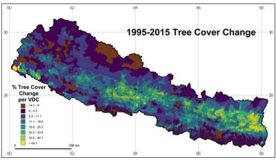
Between 1995 and 2015, a large area of degraded forests and underutilized agricultural land in the region was abandoned and replaced with tree cover. The East-West Center research project quantified the rate, extent, and socioeconomic importance of this land-use transition based on three decades of Landsat satellite data and spatial modeling, as illustrated by the accompanying maps.
The project team also modeled the socioeconomic and physiographic variables associated with tree-cover change and quantified their respective influences. The model shows that among socioeconomic variables, the percent of households participating in community-forestry user groups, percent of modern houses and houses with modern water supplies, and percent households with members living elsewhere were correlated with increases in tree cover. Important biophysical variables include terrain ruggedness, elevation, and aspect (north-facing slopes are less suited to agriculture and hence have more tree cover).
The research team consists of scholars with extensive experience in studies of land-cover and land-use change in mountainous regions, including Nepal, and with access to national and sub-national networks of decision-makers, academics, and activists. The Principle Investigator, Jefferson Fox (EWC), oversees the project and coordinates work with co-investigators in Nepal. Sumeet Saksena (EWC) assists Dr. Fox in overseeing the project and provides support on statistical analysis and modeling. J. Van Den Hoek (Oregon State University) and Kaspar Hurni (University of Bern, Switzerland) focus on remote sensing and global information systems. Other colleagues involved in the project are Ram Chhetri (Resources Himalaya Foundation), Pitamber Sharma (Resources Himalaya Foundation, former Vice-Chairman of the National Planning Commission of Nepal), and Alexander Smith (Oregon State University).
From 29 November to 4 December 2018, Center scholars took part in an international conference and hands-on workshop in Kathmandu designed to discuss the rate, extent, and socioeconomic importance of Nepal’s tree transition based on three decades of Landsat satellite data and spatial modeling. The meeting had four overarching themes: (1) Describing project methodologies (satellite image processing, census and interview data analysis, and spatial modeling); (2) Documenting annual tree-cover change since 1990; (3) Identifying physiographic and socioeconomic variables associated with tree-cover change and quantifying their respective influences; and (4) Assessing how foreign labor migration and remittances correlate with tree cover and the future of community forestry in Nepal.
A short report on the conference and workshop is available. Background information and presentations made at the meeting are available on the South/Southeast Asia Research Initiative (SARI) website.
Related publications
Hurni, Kaspar, Jamon Van Den Hoek and Jefferson Fox (2019). Assessing the spatial, spectral, and temporal consistency of topographically corrected Landsat time series composites across the mountainous forests of Nepal. Remote Sensing of Environment. 231:111225.
Fox, Jefferson (2018). What happens to the natural environment when a rural community joins the global economy? East-West Wire. Honolulu: East-West Center.
Fox, Jefferson (2016). Community forestry, labor migration, and agrarian change in a Nepali village: 1980 to 2010. The Journal of Peasant Studies. http://dx.doi.org/10.1080/03066150.2016.1246436.
Since the 1980s, Nepal, one of the poorest countries in the world, has gained worldwide recognition for path-breaking achievements in community forest management. In 1988, Nepal’s Department of Forests designated 61 percent of the nation’s total forest area (3.5 million hectares) as forest that could be transferred legally to local communities and managed for their benefit. Today, community forests occupy nearly 23 percent of Nepal’s total forest area (1.2 million hectares). They are managed by more than 18,000 community forest user groups comprising 1.6 million households that account for nearly 40 percent of Nepal’s population.
The impact of this innovative system of forest management has not been documented, however, in part due to the difficulty of mapping forest cover in mountainous environments. The East-West Center is conducting a multi-disciplinary research program that seeks to quantify the rate and extent of Nepal’s forest transition and identify associated socioeconomic variables. Data have been collected and analyzed on two nested scales: the Middle Hills as a whole and local community forests in the region.
Between 1995 and 2015, a large area of degraded forests and underutilized agricultural land in the region was abandoned and replaced with tree cover. The East-West Center research project quantified the rate, extent, and socioeconomic importance of this land-use transition based on three decades of Landsat satellite data and spatial modeling, as illustrated by the accompanying maps.
The project team also modeled the socioeconomic and physiographic variables associated with tree-cover change and quantified their respective influences. The model shows that among socioeconomic variables, the percent of households participating in community-forestry user groups, percent of modern houses and houses with modern water supplies, and percent households with members living elsewhere were correlated with increases in tree cover. Important biophysical variables include terrain ruggedness, elevation, and aspect (north-facing slopes are less suited to agriculture and hence have more tree cover).
The research team consists of scholars with extensive experience in studies of land-cover and land-use change in mountainous regions, including Nepal, and with access to national and sub-national networks of decision-makers, academics, and activists. The Principle Investigator, Jefferson Fox (EWC), oversees the project and coordinates work with co-investigators in Nepal. Sumeet Saksena (EWC) assists Dr. Fox in overseeing the project and provides support on statistical analysis and modeling. J. Van Den Hoek (Oregon State University) and Kaspar Hurni (University of Bern, Switzerland) focus on remote sensing and global information systems. Other colleagues involved in the project are Ram Chhetri (Resources Himalaya Foundation), Pitamber Sharma (Resources Himalaya Foundation, former Vice-Chairman of the National Planning Commission of Nepal), and Alexander Smith (Oregon State University).
From 29 November to 4 December 2018, Center scholars took part in an international conference and hands-on workshop in Kathmandu designed to discuss the rate, extent, and socioeconomic importance of Nepal’s tree transition based on three decades of Landsat satellite data and spatial modeling. The meeting had four overarching themes: (1) Describing project methodologies (satellite image processing, census and interview data analysis, and spatial modeling); (2) Documenting annual tree-cover change since 1990; (3) Identifying physiographic and socioeconomic variables associated with tree-cover change and quantifying their respective influences; and (4) Assessing how foreign labor migration and remittances correlate with tree cover and the future of community forestry in Nepal.
A short report on the conference and workshop is available. Background information and presentations made at the meeting are available on the South/Southeast Asia Research Initiative (SARI) website.
Related publications
Hurni, Kaspar, Jamon Van Den Hoek and Jefferson Fox (2019). Assessing the spatial, spectral, and temporal consistency of topographically corrected Landsat time series composites across the mountainous forests of Nepal. Remote Sensing of Environment. 231:111225.
Fox, Jefferson (2018). What happens to the natural environment when a rural community joins the global economy? East-West Wire. Honolulu: East-West Center.
Fox, Jefferson (2016). Community forestry, labor migration, and agrarian change in a Nepali village: 1980 to 2010. The Journal of Peasant Studies. http://dx.doi.org/10.1080/03066150.2016.1246436.