

Error message
OFFICE/DEPARTMENT
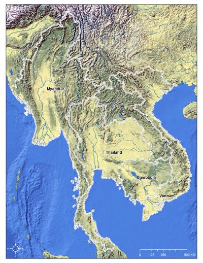
This project focused on the five countries of mainland Southeast Asia—Cambodia, Lao PDR, Myanmar (Burma), Thailand, and Vietnam—that over the past half century have witnessed a major shift from subsistence agrarian economies to commercialized agriculture and, in the case of Thailand and Vietnam, industrialization. The project studied transitions in forests, cash crops, and urban areas using remote-sensing data sources and socioeconomic databases for the 2000–2012 period.
The project had two major objectives. These were: (1) to synthesize knowledge from previous and ongoing projects in mainland Southeast Asia; and (2) to enhance the conceptual underpinnings of land-change science by integrating aspects of land teleconnections, land-use transitions, and political ecology in order to link land changes to local, national, and international drivers. At the regional scale, work focused on changes in forests and cash crops in upland areas above 300 meters above sea level, as well as on urban expansion.
Mapping changes in tree-dominated landscapes in mainland Southeast Asia is challenging because of the diverse types of tree covers—ranging from the secondary forests associated with shifting cultivation, deforestation, and afforestation to the expansion of new tree crops, as well as processes of change (e.g., natural vs. planted forests and temporal dynamics related to shifting cultivation vs. expansion of permanent agriculture). Mapping peri-urbanization is also challenging because there is no single standard method for defining or delineating these complex, heterogeneous areas.
At the local scale, work centered on sites in Lao PDR and Cambodia where the hasty expansion of cash crops is of international concern, and in Vietnam where urbanization is particularly rapid. In these three countries, rapid change was mapped and documented for a sample of sites in great spatial and temporal detail. By integrating aspects of land-change science and actor-network theory with remote-sensing data, the project produced an integrated understanding of land-cover and land-use change in areas of expanding cash crops and perirubanization. The project documented not only how distant drivers affect land-cover and land-use changes in a collection of sample sites, but also how those changes drive other, distant land-cover and land-use changes. This work provides an empirical understanding of political, economic, and social forces driving land-cover and land-use change at the local level.
With support from the US government's National Aeronautics and Space Administration (NASA), project activities took place from 2014 to 2018. They generated a number of reports and other documents. Research was linked to three of NASA's priority science themes: synthesis studies; detection and monitoring of land-cover and land-use change; and drivers of change.
Project team
The research team consisted of well-established scholars from four institutions: the East- West Center (EWC); the Centre for Development and Environment (CDE) of the University of Bern; the University of Wisconsin at Madison (UW); and Colorado State University (CSU). The team possessed extensive experience in the region and access to regional and national networks of decisionmakers, academics, and activists. Team members were all highly experienced at working in interdisciplinary, multicultural environments across geographic distances.
Jefferson Fox (EWC), the Principal Investigator, studies land-use and land-cover changes in Asia and the possible cumulative impact of these changes on the region and the global environment. His recent research projects have included Modernization and Emerging Infectious Diseases: The Case of Avian Influenza in Vietnam, funded by the U.S. National Science Foundation (NSF), and Economic Development and Land-Use Change: Expansion of Cash Crops in Southeast Asia, funded by NASA.
Annemarie Schneider (UW) examines the causes and consequences of land-cover change in urban and peri-urban environments. Her recent work has included monitoring and modeling the demographic, economic, and policy changes responsible for rapid urbanization in China and mapping urban expansion and agricultural land loss over large areas using Landsat and MODIS data. She has more than a decade of experience leading and executing multidisciplinary remote-sensing-based projects using a range of satellite data types, advanced machine-learning technologies, data-fusion techniques, and in-situ data collection.
Andreas Heinimann's (CDE) research focuses on landscape transformations and their ecosystems and development trade-offs under global change as well as sustainability science and sustainable development, with a special focus on human-environment interactions in developing countries. He is a member of the Scientific Steering Committee of the Global Land Project (GLP) of the International Geosphere-Biosphere Programme (IGBP) and the International Human Dimension Programme on Global Environmental Change (IHDP).
Stephen Leisz's (CSU) work focuses on land-use/land-cover changes in upland Southeast Asia with specific emphasis on linkages to changing farming and livelihood systems, especially changes in shifting cultivation, and drivers of these changes. Leisz has worked with agent-based models and systems models as well as Landsat, SPOT, ASTER, MODIS, and GeoEye/Digital Globe imagery.
Kaspar Hurni (CDE/EWC) focuses on the detection of land transformations in Lao PDR using remote-sensing data at different spatial and temporal resolutions and GIS approaches, linking patterns to processes and characterizing changes.
Ian Baird's (UW) research is focused on land-tenure and livelihood issues and large-scale land concessions related to cash crops (particularly rubber, but also other crops) in Lao PDR and Cambodia. He has extensive experience working in Lao PDR and Cambodia, including relevant language abilities and strong contacts in mainland Southeast Asia.
Regional counterparts include K. Phanvilay (National University of Laos), T.D. Vien (Hanoi University of Agriculture), and H. Kimkong (Royal University of Phnom Penh).
Related publications
Ahrends, Antje, Peter M. Hollingsworth, Alan D. Ziegler, Jefferson M. Fox, Huafang Chen, Yufang Su, and Jianchu Xu (2015). Current trends of rubber plantation expansion may threaten biodiversity and livelihoods. Global Environmental Change. 34:48-58.
Baird, Ian G., and Jefferson Fox (2015). How land concessions affect places elsewhere: Telecoupling, political ecology, and large-scale plantations in Southern Laos and Northeast Cambodia. Land. 4(2): 436-53.
Baird, Ian G., William Noseworthy, Nghiem Phuong Tuyen, Le Thu Ha, and Jefferson Fox (2018). Land grabs and labour: Vietnamese workers on rubber plantations in southern Laos. Singapore Journal of Tropical Geography. 40 (1): 50-70.
Castrence, Miguel, Duong H. Nong, Chinh C. Tran, Luisa Young, and Jefferson Fox (2014). Mapping urban transitions using multi-temporal Landsat and Dmsp-Ols night-time lights imagery of the Red River Delta in Vietnam. Land. 3(1): 148-66.
Choenkwan, Sukanlaya, Jefferson M. Fox, and A. Terry Rambo (2014). Agriculture in the mountains of northeastern Thailand: Current situation and prospects for development. Mountain Research and Development. 34(2): 95-106.
Fox, Jefferson, Tuyen Nghiem, Ham Kimkong, Kaspar Hurni, and Ian G. Baird (2018). Large-scale land concessions, migration, and land use: The paradox of industrial estates in the Red River Delta of Vietnam and rubber plantations of Northeast Cambodia. Land. 7(2), 77; https://doi.org/10.3390/land7020077.
Hurni, Kaspar, and Jefferson Fox (2018). The expansion of tree-based boom crops in Mainland Southeast Asia: 2001 to 2014. Journal of Land Use Science. 13(1–2): 198–219.
Hurni, Kaspar, Annemarie Schneider, Andreas Heinimann, Nong Huu Duong, and Jefferson Fox. (2017). Mapping the expansion of boom crops in Mainland Southeast Asia using dense time stacks of Landsat data. Remote Sensing. 9(4): 320-326.
Kontgis, Caitlin, Annemarie Schneider, Jefferson Fox, Sumeet Saksena, James H. Spencer, and Miguel Castrence (2014). Monitoring peri-urbanization in the greater Ho Chi Minh City metropolitan area. Applied Geography. 53:377-88.
Kontgis, Caitlin, Annemarie Schneider, and Mutlu Ozdogan (2015). Mapping rice paddy extent and intensification in the Vietnamese Mekong River delta with dense time stacks of Landsat data. Remote Sensing of Environment. 169:255-69.
Mertes, C.M., Annemarie Schneider, D. Sulla-Menashe, A.J. Tatem, and B. Tan (2014). Detecting change in urban areas at continental scales with MODIS data. Remote Sensing of Environment. 158:331-47.
Nong, Huu Duong, Christopher A. Lepczyk, Tomoaki Miura, and Jefferson M. Fox (2018). Quantifying urban growth patterns in Hanoi using landscape expansion modes and time series spatial metrics. PloS one. 13(5): p.e0196940.
Nong, Huu Duong, Jefferson Fox, Tomoaki Miura, and Sumeet Saksena (2015). Built-up area change analysis in Hanoi using support vector machine classification of Landsat multi-temporal image stacks and population data. Land. 4(4): 1213–31.
Schneider, Annemarie (2012). Monitoring land cover change in urban and peri-urban areas using dense time stacks of Landsat satellite data and a data mining approach. Remote Sensing of Environment. 124:689–704.
Shirai, Yuko, Jefferson Fox, Stephen J. Leisz, Hayao Fukui, and A. Terry Rambo (2017). The influence of local non-farm employment on rural household structure in Northeast Thailand. Journal of Rural Studies. 54:52–59.
Shirai, Yuko, Stephen J. Leisz, Jefferson Fox, and A. Terry Rambo (2017). Rural household characteristics and agricultural activities in relation to local non-farm employment: A comparative study of two wet-rice-growing villages in Northeast Thailand. Khon Kaen Agriculture Journal. 45(4): 721–30.
Shirai, Yuko, Stephen Leisz, Jefferson Fox, and A. Terry Rambo (2019). Commuting distances to local non‐farm workplaces and out‐migration: The case of Northeast Thailand. Asia Pacific Viewpoint. 60(3); 280–95.